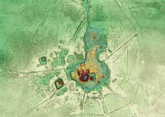
LiDAR shots taken through forest canopies have revealed traces of extensive ancient settlements, such as this one at a mound called Cotoca in the Bolivian Amazon. Darker colors indicate greater elevation. (Image courtesy of Carla Jaimes Betancourt, University of Bonn)
For decades, agricultural development and rainforest conservation in Latin America have seemed unalterably at odds, with ranching and farming typically involving wholesale land clearing, biodiversity destruction, drying of the microclimate and severe erosion in times of heavy rains. Beneath the tree canopy, however, traces of a more harmonious model of forest stewardship and food production is being glimpsed.
There, scientists using laser technology have uncovered traces of surprisingly sophisticated land-management practices employed by pre-Columbian Indigenous societies—methods, they argue, that could inform today’s world as it tries to balance the goals of food security and climate protection.
Archeologists say these societies took a multifaceted approach to land management, one in which they worked with nature rather than against it. The model, they say, contrasts starkly with modern industrial farming, which has hinged on the displacement of natural forest—a process that has caused heavy environmental damage as vast areas are converted into monoculture cropland or pasture for livestock.
Key to the insights is a growing body of research that uses laser technology called Light Detection and Ranging (LiDAR), which allows scientists to see through the forest canopy and capture images of underlying land forms. The findings have prompted archeologists to radically rethink the nature and size of pre-Columbian Indigenous populations.
“It’s the perfect tool to see the earthworks under the forest,” says archeologist Stéphen Rostain of the National Center of Scientific Research (CNRS) in Paris. “We are discovering remarkable things.”
First developed by the U.S. military for reconnaissance and terrain mapping during the Cold War, LiDAR today has various industrial applications, including sensors in driverless cars. It is also being put to such uses as gauging the carbon-storage capacity of forests or hunting for traces of ancient civilizations.
LiDAR systems mounted in planes overflying the forest fire billions of laser pulses. Many bounce back from the canopy but, as treetops are porous, some reach the ground. Together these pulses provide an accurate three-dimensional map of both the forest canopy and ground features below it, information that can reveal hitherto undetected natural or manmade landforms.
An early use of LiDAR in Latin American archeology occurred in 2010 when a multidisciplinary team from the University of Central Florida gauged the scale of a sprawling archeological site, known as Caracol, located in current-day western Belize. Its Mayan population occupied the site for about 1,500 years (roughly 600 BC to 900 AD) and is believed to have peaked at 115,000 inhabitants. The team applied LiDAR over an extensive region, accomplishing more in less than a week than archeologists hacking through the jungle would have achieved in a quarter of a century.
Arlen Chase, a University of Houston anthropologist who headed the team, calls the results “stunning.” He says the LiDAR images have helped experts dispel preconceived notions that Mayan civilizations were limited in size and sophistication, revealing the Maya had modified much of the landscape. “LiDAR is clearly the tool that Maya archeologists have been waiting for,” Chase says. Since then, his team has collected significantly more LiDAR data and are using it to investigate other characteristics of Caracol society, such as wealth distribution.
LiDAR was also used in 2019 in a German-Bolivian expedition to Llanos de Moxos, a tropical savanna in the Bolivian Amazon. Evidence of sophisticated pre-Columbian agriculture involving raised fields and extensive water channels had already been found in the region, inspiring attempts by present-day farmers to adopt certain aspects of it. (See "Amazon farmers look to past for new model" —EcoAméricas, March 2014.) But in a May 2022 Nature article, archeologists reported that LiDAR monitoring had uncovered a vast, surrounding network of settlements constituting a “low-level urbanism.”
The 120,000-square-kilometer (46,000-sq.-mile) region has been inhabited for about 10,000 years, initially by hunter-gatherers. Around 1000 BC, more complex societies developed and made their surroundings more resilient in the face of difficult environmental conditions, including severe seasonal flooding. LiDAR helped detail how, without local sources of stone and domesticated animals, these societies managed to build a sophisticated array of earthwork structures for homes, religious ceremonies, burial grounds and agricultural use. The archeologists say a large population, possibly as many as a million people, inhabited the region.
For about 900 years (circa 500 AD-1400 AD) the Casarabe people dominated the area, building two large settlements, one of which involved moving a remarkable 570,000 cubic meters (20 million cubic feet) of earth, enough to fill more than 200 Olympic-sized swimming pools. The settlements had stepped platforms which were sometimes topped by pyramids 22 meters (72 feet) tall. They were connected to neighboring communities by raised causeways stretching for several miles and surrounded by canals, reservoirs, and artificial lakes.
More recently LiDAR was used in an interdisciplinary project in the Brazilian Amazon. Scanning an area of 5,315 square kilometers (2,052 sq. miles), just 0.07% of the whole Brazilian Amazon, they discovered 24 unknown earthworks, consisting of ditches, paths, and wells. They were able to calculate, with 90% of probability, that there are at least 10,000, and possibly 23,000, earthworks beneath the forest canopy. The results were published in an October 2023 article in the journal Science. The earthworks were heavily concentrated in the southwestern Brazilian Amazon, corroborating earlier studies that had found this region to be a hotspot of earth-building societies.
Just as remarkable was a study of the Upano River valley in the eastern foothills of the Andes mountains in Ecuador. Building on over two decades of interdisciplinary investigations, this LiDAR-based study showed that the Upano River valley was the site of the largest pre-Columbian urban network known in Amazonia, dating back some 2,500 years. It revealed an elaborate human-made landscape suggesting a vast city, one featuring 6,000 earthen platforms. The authors said the settlements were as complex as those found in Llanos de Moxos and were “1,000 years older.”
Rostain, the CNRS archeologist and the study’s lead author, says LiDAR has helped settle a question that came up early in his career. “I have been working in the Amazon for 40 years,” he notes. “A long while ago, when I was carrying out my Ph.D. in French Guiana, I discovered many small mounds that I realized were used for farming. I found it difficult to persuade people, particularly scientists, that the mounds were human-made.” Research of the kind conducted in the Upano River valley, Rostain adds, have put such doubts to rest.
The former settlements detected in the Amazon had diverse cultures, but experts note some common features. In Llanos de Moxos in Bolivia, for instance, LiDAR revealed that roads radiated out from the two centers like spokes on a wheel, stretching for several miles. And buildings set along the spokes were all sited to face in a north-northwesterly direction. Archeologists suspect such features reflect the Casarabe people’s cosmology. “They remolded the landscape in terms of their cosmology, which is mind-blowing,” says Chris Fisher, a Colorado State University archeologist.
In Ecuador’s Upano River valley, the platforms were distributed in a geometric pattern and intertwined with a complex road system extending over tens of miles and connecting different urban centers. The roads are straight with right angles, which is “much harder to build than one that fits into the landscape,” notes study co-author Antoine Dorison.
Says the study: “It is tempting to see the Upano valley’s geometrical layout, which cuts across the topography, as a cosmological design rather than a common and practical system of communication.”
At other sites, the evidence is less clear. In several locations in Brazil, including along the coast of Amapá in the far north, LiDAR detected ceremonial sites with megaliths—that is, large stone monuments—arranged in circular clusters, which the archeologists believe may be linked to their cosmology. In Belize, Chase observes that while cosmology clearly interested Caracol’s Mayans, it did not appear to influence the routes of the causeways linking markets and administrative centers.
A key question being examined in the new research is how the pre-Columbian societies managed to feed their large populations. LiDAR has helped reveal agricultural terraces as one of the answers, Chase says. “We had documented these structures in on-the-ground surveys, but it had been near-impossible to imagine the extent of the modified landscape,” he says.
Chase notes his team found 160 square kilometers (62 sq. miles) of terraces shaped to fit the land’s contours and take advantage of natural drainage. Observes Chase: “[E]ven today they have not been breached by Caracol’s heavy rains, though they have been abandoned for over 1,000 years.”
Chase says these terraces were designed not only to control water flow during the rainy season, thereby minimizing erosion, but also to retain water for use in irrigation. The Mayans produced multiple harvests of maize, beans, squash, and other crops in a single year, and nutrients were replenished by fertilizing the earth with human excrement and compost. He says the agricultural terrace system supplied the daily needs of over 100,000 city dwellers. Similarly, in Bolivia vast water-management infrastructure enabled the Casarabe to cultivate a diversity of crops—with maize the primary staple—farm fish, and herd wild animals to facilitate hunting.
Rostain was impressed by the farming skill of the communities in the Upano River valley in Ecuador. “The Upano valley is very wet, so if you want to cultivate, you need drainage,” he says. “And through LiDAR we found a checkerboard of drainage, with huge surfaces modified for agricultural purposes.”
Food was cultivated in areas between some 6,000 raised settlement platforms, each measuring 20 meters (66 feet) by 10 meters (33 feet), and on terraces built on slopes. Maize was the main crop, along with some Amazon native plants, medicinal plants, and fruit. They also raised fish for protein.
The LiDAR survey in Brazil suggests that the ways of feeding the populations varied from region to region, largely due to differing environmental conditions. Earthen structures were concentrated in southwestern Amazonia, particularly in present-day Acre state, with nearly none found in the other Amazonian regions. Archeologists believe this was because it was easier to form these in areas of higher temperatures and lower rainfall, as this meant they could more readily burn the forest, which had to be done before starting construction.
These locations also had soils with a better texture for earth-moving and a greater capacity to hold onto the essential nutrients needed for cultivation. They discovered that more domesticated plants were found near the structures than in other parts of the forest. These plants most often encountered were Brazil nuts (Bertholletia excelsa), breadnut (Brosimum alicastrum), a palm with edible fruits (Astrocaryum murumuru), urucuri palm (Attalea phalerata) and cacao (Theobroma cacao). They also found a greater frequency of the rubber tree (Hevea brasiliensis).
Different approaches
But the absence of earthen structures did not mean Indigenous people elsewhere in the Brazilian Amazon failed to feed their populations, just that other strategies were used. LiDAR revealed more terra preta (dark earths) in areas of few earthen structures. These soils, usually near archeological sites, hold more organic carbon and relatively high phosphorus, nitrogen, and calcium content, indicating fertility. Because they contain organic matter from food remains such as fish and animal bones, many archeologists believe Indigenous people helped produce these dark earths.
The discoveries made through LiDAR could have important political consequences, one of which is to strengthen Indigenous claims to the land. This point was raised in last year’s interdisciplinary article on Brazil. The coauthors wrote that despite the rights given to Indigenous peoples in Brazilian law to occupy traditional lands, only 9% of all 937 known earthworks are located inside Indigenous lands or protected areas. And most earthworks were found in the “Arc of Deforestation” along the southern and eastern edges of the Amazon forest, which has the highest rates of land-clearing.
“Ironically, modern-day deforestation is removing the very evidence of pre-Columbian land-use strategies that were able to transform the landscape without causing large-scale deforestation,” the researchers wrote in the study. They call for “strong government policies and law enforcement” to ensure protected areas and Indigenous territories serve as barriers to the illegal activities destroying Amazonia’s natural and cultural heritage.
Reassessment required
Another conclusion highlighted in recent studies is the need to re-examine assumptions about pre-Columbian Indigenous societies. Carla Jaimes Betancourt, a professor of archeology at the University of Bonn, believes many of these societies probably evolved separately.
“The Amazon, spanning an area equivalent to the European continent, stands out not only for its vastness but also its wealth of cultural diversity,” she says. “Recent archeological and linguistic investigations have illuminated a past Amazon even more diverse than its present state. Notably, the emerging cities in Upano, Ecuador, Llanos de Moxos, Bolivia, and Acre, Brazil, exhibit distinct characteristics, suggesting they may not share a direct connection.”
Last year’s study of Brazil recommends a reassessment of the speed at which each of these societies evolved. The extraordinary diversity of pre-Columbian societies and their land-use practices over 12,000 years, the study says, means “forests were likely modified at varying intensities by different Indigenous populations through time.” The archeologists are emphatic that Indigenous knowledge could be a key asset in the struggle to curb global climate change. They cite myriad techniques employed, ranging from contour-hugging agricultural landforms “co-constructed” with nature to the use of insects and worms to improve soil structure.
Such approaches deserve close attention, they argue, as weather grows more extreme and the need for ecosystem services including water conservation, biodiversity protection and carbon storage becomes ever more crucial. “As western people, we have had 500 years of experience in the rainforest,” Rostain says. “[Indigenous people] have had 30,000 years. They obviously knew much more about the interaction between humans and the landscape, and we must learn from them.”
- Sue Branford
In the index: Researcher works at the Caracol site in western Belize. (Photo courtesy of Caracol Archeological Project, University of Houston)