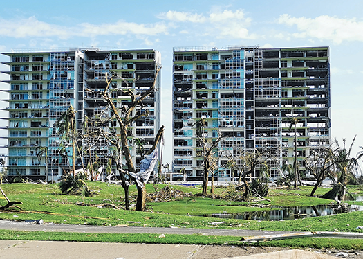
Otis left 580,000 people homeless, Mexico’s government says, and total damage was estimated at US$12-$16 billion. (Photo by Jessica Rodríguez León/Shutterstock)
It has been over five months since Hurricane Otis roared ashore on Mexico’s southwestern coast, gaining instant notoriety as the first known eastern-Pacific storm to retain Category Five power after reaching land.
“Trees were torn to pieces, as if machetes had flown through the air, shredding them,” recalls Alejandro Balanzar, who makes a living entertaining tourists as a cliff diver at La Quebrada, a famed coastal rock face in Acapulco.
While Balanzar sheltered in a ground floor bathroom with his wife, Hurricane Otis destroyed the upstairs bedroom of their concrete house overlooking Acapulco Bay. He adds: “The wind wasn’t whistling, it was screaming.”
Balanzar’s house was one of 80,000 seriously damaged homes, and a further 51,000 were totally destroyed, according to official figures.
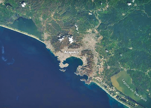
Otis made landfall near Acapulco, the capital of Mexico’s Guerrero state, at 12:25 a.m. on Oct. 25, thrashing the city with sustained winds of 165 miles per hour (265 kph). That’s 15 miles per hour (24 kph) stronger than Hurricane Patricia, which had held the record as Mexico’s most powerful Pacific coast storm since striking farther north, in Jalisco state, in 2015.
Extreme winds, storm surge and flooding associated with Otis produced an estimated US$12-16 billion in total damage, according to reinsurance and risk-analysis firms, making Otis Mexico’s most costly tropical cyclone.
The Mexican government reports that Otis killed 52 people, left 580,000 homeless, and damaged or destroyed an urbanized swath of 7,000 hectares (17,000 acres), but in the months since the storm, the death toll has been widely criticized as understated.
An investigation by local media that drew on information gathered from local funeral homes calculated that the storm caused 350 deaths. A range of civil society actors say the loss of life was far higher than that, charging that the government has deliberately downplayed the disaster’s impacts to minimize bad press in the run-up to Mexico’s June 2 general elections.
Criticism of the government’s handling of the hurricane also focuses on the meteorological alert system that was ostensibly designed to give residents fair warning of looming storms. In Acapulco, that system relies in part on a solar-powered meteorological outpost that the Mexican Navy operates on La Roqueta, a 45-hectare (111-acre) island known for its tropical fish species, corals, iguanas and small reptiles.
Benjamín Martínez, a meteorologist with the National Autonomous University of Mexico (UNAM), describes Mexico’s meteorological monitoring and tools as limited. He says that currently, its national meteorological service sends weather data to the U.S. National Oceanic and Atmospheric Administration (NOAA) so they can be entered into the U.S. agency’s models.
NOAA collaborates with the World Meteorological Organization (WMO), a UN agency, by making forecasts and issuing warnings on behalf of the WMO for North and Central America and the Caribbean. But the raw data Mexico sends NOAA for forecasting purposes is “inadequate,” Martínez says.
Evidence of the problem, he asserts, is that just 24 hours before Otis reached Category 5 status, the U.S. National Hurricane Center, a division of NOAA, was still forecasting a tropical storm with wind speeds of 70 miles per hour.
That’s less than half the force Otis brought to bear when it ultimately made landfall, having doubled its wind speed in just 12 hours. The storm caught Acapulco’s population of over one million largely unprepared.
Martínez says the disaster illustrates the danger of depending on forecasts from abroad. “Mexico should really have its own adequate forecast systems in place and not rely on the U.S.,” he says.
Rosario Romero Centeno, a researcher at UNAM’s Institute for Atmospheric Sciences and Climate Change since 2009, takes a different view. She agrees that Mexico needs to improve its capabilities, but with the objective of improving the quality of the information it shares with international partners.
“Mexico has everything to gain from international collaboration, especially since NOAA has so many tools available,” says Romero, who holds a master’s degree in ocean physics and a doctorate in atmospheric physics. She adds: “What Mexico needs is to increase monitoring capacity so that we have more specific data about our own territory which can increase forecasting precision.”
The international forecasting models Mexico has access to in its relationship with NOAA bring mathematics, physics and enormous computing power to bear in parsing the various geographical and weather factors present in storms. Romero, whose research focuses on Mexican climate variation stemming from the interaction of the atmosphere and the ocean, says NOAA’s advanced forecasting tools represent a vital source of information.
“NOAA has the capacity, in terms of technology and personnel, to run many models at once and do an ensemble of the forecasts from a variety of programs, each of which can predict different trajectories and intensities,” she says. “Studies have shown that ensemble forecasts are far more precise than relying on a single program’s forecast.”
Robbie Berg, a senior hurricane specialist at NOAA’s National Hurricane Center, is part of a team of 11 that forecasts storm intensity and size for North America’s Atlantic and Pacific coasts, including Mexico.
Berg says that weather- and ocean-monitoring information is entered into a model, which is then run multiple times as the data are adjusted in order to calculate ranges of outcomes for forecasters to weigh.
Experts assert Mexico’s Pacific Coast meteorological infrastructure is in a state of overall neglect compared to the country’s Gulf of Mexico region, lacking weather buoys and Doppler weather radar, among other key capabilities.
Monitoring capability for the Gulf, by contrast, has benefited from investment made by Pemex, the state-owned oil company, to protect its drilling platforms and oil installations there. The Gulf region also benefits from NOAA infrastructure and know-how because of the proximity to and overlap with U.S. coastal areas.
Berg says NOAA receives information from Pemex, but that it is not “consistent.” Martínez, for his part, deems data from the Pacific Coast far less useful: “It is clear that investment in the Pacific [Coast region] has been poor because, there, the economic incentive is not as great as it is in the oil-rich Gulf.”
In theory, monitoring technologies that could be brought to bear range from weather buoys to radar to advanced hurricane-hunter planes. But only the United States uses hurricane hunters, and when it comes to lower-tech options, Mexico’s capability is uneven at best.
“Mexico does not have any buoys in the Pacific—only in the Gulf, where they were installed to create a baseline [of readings for that region],” Romero says. Buoys in the Pacific, she says, “would also be useful to help understand and analyze the Pacific coast better.”
Next-generation tools, meanwhile, have yet to come into wide use in the countries that invented them, let alone developing nations. An example is underwater gliders, autonomous vehicles that can monitor ocean conditions at a range of depths but even in the United States are still largely in the experimental stages.
Currently, a combination of information from U.S. satellites and radar provides the most important initial forecast information, experts say. But radars situated on land have the limitation that they are only useful once a storm is approaching shore.
The most effective predictive tools, expert say, are the manned hurricane-hunter planes, which only take off when information from satellites and radars indicates a need. The planes gather information such as over-ocean wind speed, precipitation rates, and atmospheric pressure to help forecast everything from wind speed at landfall to storm-surge magnitude.
“Hurricane-hunter planes are incredibly important,” explains Berg. “They are the main way to get forecast instruments into the storm.”
Adds Berg: “One of the gaps we have wherever the storm is located is data from inside the storm itself. If we can send planes into the storm in the formative stages, that is always very helpful. It gives us a much better handle on the situation from the start. For example we can see if the storm has the right structure to strengthen. Or if the pressure is dropping, it means the storm is getting stronger, all critical information for us. But for Otis, we did not have that from the onset.”
The U.S. Air Force sent one of its 10 hurricane-hunter planes on a double pass through the eye of Otis around midday on Oct. 24, two days after Tropical Storm Otis had formed. The findings from the flight were critical, spurring NOAA to warn at about 4 p.m.: “Otis is forecast to be an extremely dangerous Category 4 hurricane when it reaches the southern coast of Mexico late tonight or early Wednesday, and preparations to protect life and property should be rushed to completion.”
Experts say that while weather radar and other monitoring infrastructure might have helped Acapulco prepare earlier for Otis, a key contributor to the disaster was the Mexican government’s delay in amplifying NOAA’s dire 4 p.m. advisory.
It was not until 8:25 p.m.—over four hours after NOAA’s announcement—that President Andrés Manuel López Obrador issued his own warning directly to citizens.
When the president took to the airwaves, Balanzar and his colleagues were still performing dives for tourists off the 35-meter- (115-foot-) high La Quebrada cliff, unaware of the approaching hurricane.
“Most of the population were totally unprepared, no one could imagine the magnitude of the life-changing moment that lay ahead,” Balanzar says. He recalls that in the immediate aftermath of Otis, he walked outside and saw his house covered in debris including corrugated roofing that had blown off other houses.
Responding to the forecast failures preceding Otis, Mexico’s National Humanities, Science and Technology Council (Conahcyt) has pledged to improve early warning systems nationwide. It has convened government and academic specialists from around the country, among them experts on hurricanes, risk management, and emergency response, to recommend upgrades to forecast models and to weather-observation networks.
Climate factor
The specialists are also being asked to use climate-change scenarios to better understand Mexico’s future vulnerability—a priority whose importance Otis dramatically underscored. In that vein, too, improved ocean and meteorological monitoring tools will be paramount.
Scientists say not enough is known to state unequivocally that climate change created the conditions for Hurricane Otis and will likely lead to more such storms. To gain that understanding, they say, scientists must learn more about what caused Otis to break records not only for its wind strength, but also for the great speed with which it reached that strength.
One factor cited is unusually high ocean temperatures. Martínez says warming waters have been registered off the coast of Guerrero and neighboring Michoacán states in recent years, noting that, unusually, water temperatures remained above 30 degrees Celsius (86 Fahrenheit) from May to October 2023.
These rising temperatures coincided with the start of the latest El Niño weather pattern, in which warming Pacific waters release heat and humidity into the atmosphere—key precursors of storm activity.
When a storm whips up warm surface waters, it can cause them to mix with the cooler waters below, ultimately weakening the weather system. If the warm water runs deep, however, the storm can strengthen—an effect experts believe to have been the case with Otis.
Romero says that while the number of hurricanes off Mexico is not growing, “there is an increase in intensity and the quantity of precipitation associated with each phenomenon.”
For his part, Berg says the challenge posed by Otis was its rapid intensification, which went undetected by the forecasting tools available. Rapid intensification, or RI, is defined as a windspeed increase of 35 miles per hour or greater in a day. Notes Berg: “Otis blasted the bar and went from a minimal tropical storm of some 45 miles per hour on the 23rd, to a category 4 approaching 5, major hurricane on the 24th.”
A report NOAA issued this March indicates the agency sees the forecasting performance of its National Hurricane Center during Otis as deficient. It says errors in the center’s storm-track forecasting were “much greater” than the mean for such errors during the previous five-year period, while errors in storm-intensity forecasting were “substantially larger” than the five-year mean.
“...[A]lmost every piece of intensity guidance available to forecasters for Otis was unskillful,” the report says.
Citing a “lack of observational data over the eastern Pacific Ocean,” the report says the in-storm hurricane hunter data “were crucial for forecasters to recognize that none of the models had an accurate representation of Otis’ intensity and structure.”
Adds the report: “Unfortunately, the rapid intensification of Otis was well underway by the time these data were received, and the hurricane continued to strengthen at an historic rate until it made landfall less than 12 [hours] later.”
Tourism-industry worries
Acapulco’s economy relies almost entirely on tourism, a fact that causes some experts to wonder what will become of the city if storms like Otis grow commonplace.
Indeed, tourism has been slow to return to the city, given the extensive repair and reconstruction needed. According to government figures, the hurricane damaged 80% of Acapulco’s hotels and some 5,800 commercial outlets ranging from shopping centers to restaurants. Over 4,000 of these businesses have been considered a total loss.
Environmental damage presents another hurdle, notes Robyn Sidney, founder and president of a 30-year-old nonprofit group that has fought to protect Acapulco’s La Roqueta Island from urbanization and biodiversity loss.
“Everything from fishing vessels to sport boats sank, complete with batteries, oil and many other toxic substances aboard,” says Sidney, a former New York City resident who has lived in Acapulco since 1968. “This is a major ecological tragedy for the bay.”
Adds Sidney: “The climate is changing and the people of Acapulco fear this will get worse each year. Otis is a reminder that nature makes us pay a high price.”
- Lara Rodríguez
In the index: Images show the Acapulco Bay area after Hurricane Otis struck the Mexican coast. (Photo by NOAA)
NOAA report on Otis: link